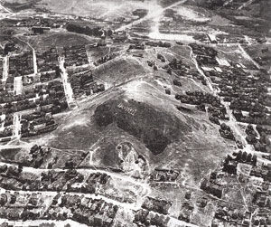
In the mid-1920s, Bernal Heights hill was used for an auto manufacturer ad and the surrounding area had lots of empty space. (Top: wetlands and San Bruno Avenue to the east; Bottom: Mission Road area to the west).
In the mid-1920s, Bernal Heights hill was used for an auto manufacturer ad and the surrounding area had lots of empty space. (Top: wetlands and San Bruno Avenue to the east; Bottom: Mission Road area to the west).
Mission Street is the boundary to the west; Cesar Chavez Street (Army Street) defines the northern border; on the east is Highway 101 and to the south was constructed Interstate 280. This defines the present area of Bernal Heights in San Francisco.
The original land grant was to Jose Cornelio Bernal (b. 1795), grandson of pioneer soldier of the de Anza party, Juan Francisco Bernal. Juan Francisco Bernal helped establish Mission Dolores a short distance northwest of his grandson’s 4,446-acre land grant named Rancho Rincon de las Salinas y Potrero Viejo in 1839. The open, rolling pasturage of the hill had been used for sheep and cattle grazing by the mission. Upon obtaining the grant, Jose constructed an adobe dwelling near the Mission Road (near St. Luke’s Hospital). Jose died shortly thereafter and his wife, Carmen, moved to the area of Ocean and Mission Road to live. After California became a state in 1850, Carmen had to fight in the courts to retain the land grant, which she did, but in the process she bankrupted herself with lawyer’s fees and lost the property.
The southern area of Bernal Heights was periodically flooded by the Islas Creek that flowed from the west and drained Mount Davidson and Twin Peaks watershed. Islas Creek is now covered over (flumed) by Interstate 280 and Alemany Boulevard which are just south of the old St. Mary’s College that was established here in 1863 by Joseph Sadoc Alemany, O.P., archbishop of San Francisco. Alemany Boulevard is named in honor of Archbishop Alemany. The college moved to Oakland in 1889 and then to Moraga, in the East Bay, in 1928. In 1924, the land was opened for development of a subdivision named St. Mary’s Park. It is a bell-shaped subdivision with streets named for the first teachers at St. Mary’s College — Agnon, Genebern and Justin; the St. Mary’s Park Recreation Center was developed to the east of the old college grounds. The entrance to St. Mary’s College opened out upon the Mission Road (El Camino Real) in the 1800s. South of St. Mary’s College, the Islas Creek ran to the east and formed an impassable marsh floodplain in the area which is now industrial/commercial businesses.
To the north of the 440-foot hill, Bernal Heights (now Bernal Heights Park), the small Precita Creek flowed along Army Street to the east and emptied into Islais Creek. It has now been covered over (flumed in 1923) and the Precita Park is what’s left of the namesake of Precita Creek.
In 1859, a toll road was constructed to the east of Bernal Hill — between Bernal Hill and the wetlands. This toll road — the San Bruno Toll Road — provided a shorter route from rapidly developing downtown San Francisco and the lower Peninsula by going around and to the east of the land barrier — San Bruno Mountain. Three main roads were now available to enter and exit San Francisco and the Peninsula — Mission Road, San Jose Road and San Bruno Toll Road.
Recommended for you
In early 1860s, the fledgling San Francisco and San Jose Railroad was constructed through the Mission District (and through the Bernal Cut) to San Jose. It terminated at Valencia and Market streets. The SF & SJ R.R. was acquired by the Southern Pacific Railroad in the later 1860s and SP began constructing its rail yards and facilities to the east along the Bay. In the 1860s, a horse-car line was built on Valencia Street and Mission Road that terminated about 30th Street where a car barn was built for storage and repair of the horse cars and later the cable cars that replaced the horse-car. This line ran from the Ferry Building, down Market Street to the Mission District. Transportation and access to Bernal Heights provided a boost to the development of the area although it was still a rural area with windmills for pumping water and outhouses. A good illustration of the individuality and independent nature of the citizens of the area is illustrated in the event associated with the animal control officer who came into the area from “uptown” looking for stray animals. When he began impounding widow O’Brien’s loose dairy cow, the whole neighborhood stood behind the widow. They beat up the animal control officer and made him “take flight” and never return to Bernal Heights. The “uptown” boys got the message.
In early 1900, a new railroad was started that built its rail shops to the southeast of the Hill. The Ocean Shore Railroad was to be a connection between San Francisco, go down the ocean shore (“It Reaches the Beaches”), through Pacifica, continue south through Half Moon Bay and connect with Santa Cruz. The 1906 earthquake put a halt to construction for a few years until it acquired enough money to continue south. The market along the coast was diluted by the advent of the automobile and business for the railroad was marginal. By 1920, the railroad was bankrupt and the facilities east of the hill were abandoned. In the 1960s, the Bayshore Freeway was constructed along the property of this railroad.
Although the 1906 earthquake devastated a lot of San Francisco, the fire and destruction never reached Bernal Heights, although it did come close. With 250,000 residents displaced by the fire and earthquake damages, Bernal Heights was used as temporary quarters for many. Exposure to the rural quality of the area resulted in an outbreak of house building and development of the roads and infrastructure. Many had found a new home to go to after the quake. The small community of Bernal Heights continued on its way to becoming a destination of artists, working men and women until it blossomed into a full-fledged community of which San Francisco could be proud.
Rediscovering the Peninsula by Darold Fredricks appears in the Monday edition of the Daily Journal.
Keep the discussion civilized. Absolutely NO
personal attacks or insults directed toward writers, nor others who
make comments. Keep it clean. Please avoid obscene, vulgar, lewd,
racist or sexually-oriented language. Don't threaten. Threats of harming another
person will not be tolerated. Be truthful. Don't knowingly lie about anyone
or anything. Be proactive. Use the 'Report' link on
each comment to let us know of abusive posts. PLEASE TURN OFF YOUR CAPS LOCK. Anyone violating these rules will be issued a
warning. After the warning, comment privileges can be
revoked.
Please purchase a Premium Subscription to continue reading.
To continue, please log in, or sign up for a new account.
We offer one free story view per month. If you register for an account, you will get two additional story views. After those three total views, we ask that you support us with a subscription.
A subscription to our digital content is so much more than just access to our valuable content. It means you’re helping to support a local community institution that has, from its very start, supported the betterment of our society. Thank you very much!


(0) comments
Welcome to the discussion.
Log In
Keep the discussion civilized. Absolutely NO personal attacks or insults directed toward writers, nor others who make comments.
Keep it clean. Please avoid obscene, vulgar, lewd, racist or sexually-oriented language.
Don't threaten. Threats of harming another person will not be tolerated.
Be truthful. Don't knowingly lie about anyone or anything.
Be proactive. Use the 'Report' link on each comment to let us know of abusive posts.
PLEASE TURN OFF YOUR CAPS LOCK.
Anyone violating these rules will be issued a warning. After the warning, comment privileges can be revoked.