The Bay Area's cold, rainy, windy weather is going to calm down briefly for the next couple of days before possibly transitioning into more storms heading into next week, according to the National Weather Service.
In the last 24 hours, rain totals across the region generally ranged from about a half an inch to nearly 2 inches.
Oakland topped out at about three-quarters of an inch, for example, while locations in the Santa Cruz Mountains measured up to about 1 1/2 inches of rain and, contrary to the typical pattern, most North Bay locations clocked in at only about a half inch, according to weather service meteorologist Rachel Kennedy.
While the total rain volume wasn't alarming, several areas were dealing with power outages Thursday morning, with PG&E reporting nearly 24,000 customers in the region with service disruptions at 8:30 a.m.
Roughly half of those affected had power restored about two hours later, according to PG&E.
Along with the rain came frosty temperatures and a light dusting of snow at higher-elevation places like Mt. Diablo, Mt. Saint Helena, the Santa Cruz Mountains and the eastern Santa Clara Hills.
Recommended for you
While Thursday will be characterized by scattered showers, the sun should start peeking through storm clouds in many places and Friday is expected to be rain-free.
Temperatures will remain on the cold side Thursday night and into Friday morning as the weather system moves to the east, with rain a possibility for Saturday.
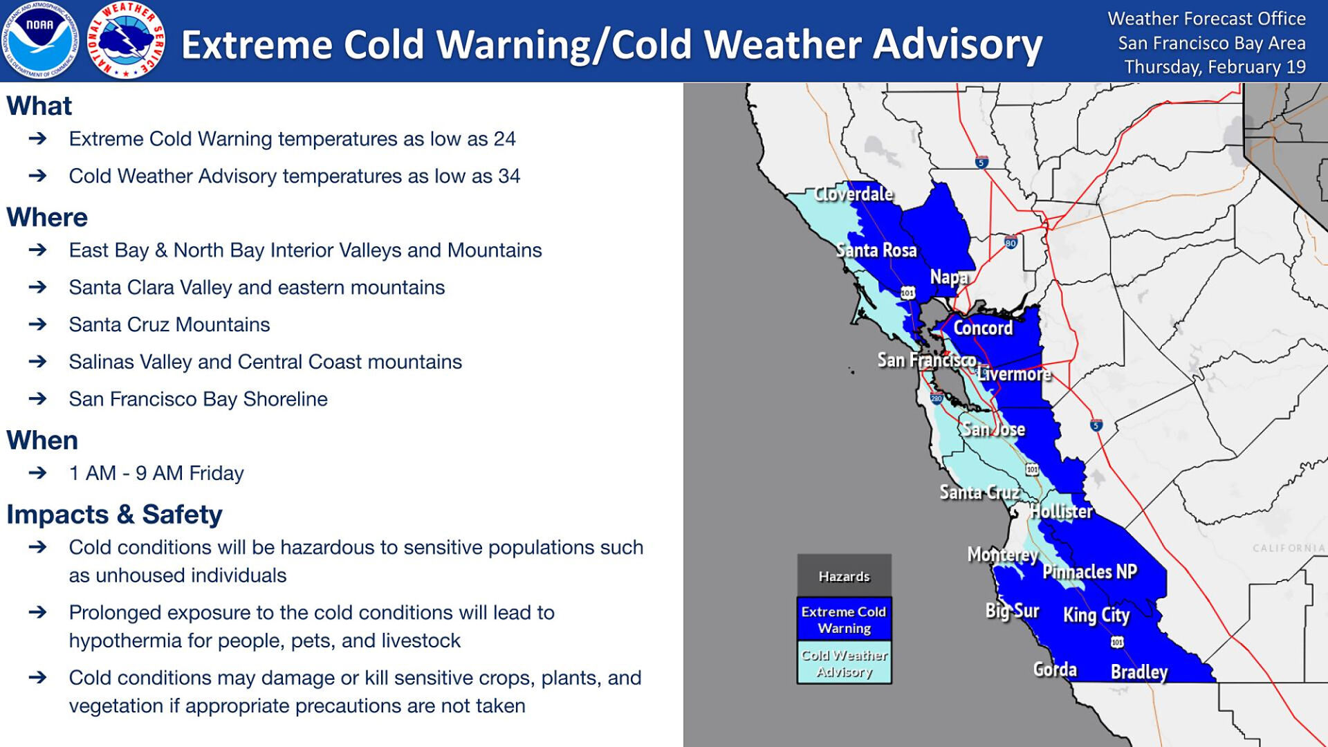
During that time, much of the region will be under an Extreme Cold Warning or Cold Weather Advisory, with low temperatures hitting between 24 degrees inland to 34 degrees closer to the Bayside and coastal areas from 1 a.m. to about 9 a.m. Friday.
"We'll have showers through rest of today, then will be on dryer side on Friday and Saturday," Kennedy said.
An unsettled pattern will move in late Saturday and Sunday with rain chances lingering for much of next week, she said.
"This is a typical storm for us, the most unusual part of it is the low temperatures," she said.
Keep the discussion civilized. Absolutely NO
personal attacks or insults directed toward writers, nor others who
make comments. Keep it clean. Please avoid obscene, vulgar, lewd,
racist or sexually-oriented language. Don't threaten. Threats of harming another
person will not be tolerated. Be truthful. Don't knowingly lie about anyone
or anything. Be proactive. Use the 'Report' link on
each comment to let us know of abusive posts. PLEASE TURN OFF YOUR CAPS LOCK. Anyone violating these rules will be issued a
warning. After the warning, comment privileges can be
revoked.
Please purchase a Premium Subscription to continue reading.
To continue, please log in, or sign up for a new account.
We offer one free story view per month. If you register for an account, you will get two additional story views. After those three total views, we ask that you support us with a subscription.
A subscription to our digital content is so much more than just access to our valuable content. It means you’re helping to support a local community institution that has, from its very start, supported the betterment of our society. Thank you very much!


(0) comments
Welcome to the discussion.
Log In
Keep the discussion civilized. Absolutely NO personal attacks or insults directed toward writers, nor others who make comments.
Keep it clean. Please avoid obscene, vulgar, lewd, racist or sexually-oriented language.
Don't threaten. Threats of harming another person will not be tolerated.
Be truthful. Don't knowingly lie about anyone or anything.
Be proactive. Use the 'Report' link on each comment to let us know of abusive posts.
PLEASE TURN OFF YOUR CAPS LOCK.
Anyone violating these rules will be issued a warning. After the warning, comment privileges can be revoked.