A plan to add 50 miles of bike lanes in South San Francisco — nearly doubling the city’s current mileage — and make sweeping improvements to boost pedestrian safety, was released this week by city planners.
Called the Active South City Bicycle and Pedestrian Master Plan, the document’s been in the works since 2018 as the city worked to identify its most dangerous roads, as well as conduct outreach to residents on where they would like to see changes.
“Our streets are not safe,” Planning Commissioner Sarah Funes Ozturk said. “I’m really excited about this plan, I think it’s going to be so important to the next generation of bicyclists.”
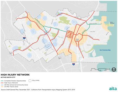
The plan identifies a “high injury network” of streets where most collisions in the city have occurred, and where safety improvements will be concentrated. El Camino Real and Westborough, Airport and Hillside boulevards all make the list, as do several downtown corridors. Noted was that recorded pedestrian fatalities were concentrated in the downtown area.
The city also found many collisions involving cyclists and car drivers were occurring where bike lanes already exist, Senior City Planner Christopher Espiritu said. Nearly half of the city’s existing “bike lanes” are no more than arrows calling for the road to be shared, painted on lanes used by cars.
That would change per the new plans, with 22 miles of protected bike lanes — those separated from cars with plastic posts or other physical elements — called for to either replace existing unprotected lanes or be built where no lane currently exists. Roughly 17 miles of shared lanes, called class 3 bike lanes by the state, would remain.
Protected lanes could be added along El Camino Real, Junipero Serra Boulevard, Westborough Boulevard, Airport Boulevard, Bayshore Boulevard and East Grand Avenue, among several other streets. The plan, however, notes these areas would require further study, as road capacity, parking and other operations could be impacted.
“I understand we like to have wider roads, but we can’t put safety on the back burner,” Commissioner Norm Faria said, alluding to compromise. “We can’t take the safety of pedestrians and bicycles for granted.”
Espiritu said each individual project would require its own environmental study, per the California Environmental Quality Act, which takes into account things like traffic impacts and neighborhood opposition. The City Council will also need to sign off on projects.
Additionally, funding sources still need to be identified. Some money will come from fees paid by developers, and money could come from the city’s general fund. But the majority will be sought from state and federal grants, Principal Planner Billy Gross said.
Recommended for you
“The amount of fees that we’re going to get from the citywide transportation impact fee is not enough to cover all the projects we’re identifying, far short,” he said. “So we’re going to have to look for every funding source possible.”
Also, some developers will pay for improvements directly, as is the case of two residential buildings slated for Airport Boulevard, where developers are covering a redesign for an adjacent intersection and upgrades to a nearby pedestrian tunnel.
“The city can find money for many things, but this is an asset to our citizens and their safety,” Faria said.
Regarding pedestrian improvements, 40 intersections are recommended for things like improved crossing, including better lighting and signage, curb extension or ramps. Various streets could also get sidewalks added.
Programming and policies could complement new infrastructure as well, including wayfinding assistance with online maps for cyclists and pedestrians, and expanding bike parking requirements.
The plan states a goal of improving inter-neighborhood connectivity, and helping residents feel safe and comfortable making short trips around town by walking or biking instead of using a car. The last similarly-oriented plans were adopted in 2011, with the Pedestrian Master Plan, and 2014, with the Bicycle Master Plan.
Espiritu noted many of the projects recommended in those plans had already been carried out, save for some more complex projects that require additional study and funding.
The Planning Commission Thursday unanimously voted to recommend the City Council adopt the new plan. The City Council will review and vote on adoption at a future meeting.
Keep the discussion civilized. Absolutely NO
personal attacks or insults directed toward writers, nor others who
make comments. Keep it clean. Please avoid obscene, vulgar, lewd,
racist or sexually-oriented language. Don't threaten. Threats of harming another
person will not be tolerated. Be truthful. Don't knowingly lie about anyone
or anything. Be proactive. Use the 'Report' link on
each comment to let us know of abusive posts. PLEASE TURN OFF YOUR CAPS LOCK. Anyone violating these rules will be issued a
warning. After the warning, comment privileges can be
revoked.
Please purchase a Premium Subscription to continue reading.
To continue, please log in, or sign up for a new account.
We offer one free story view per month. If you register for an account, you will get two additional story views. After those three total views, we ask that you support us with a subscription.
A subscription to our digital content is so much more than just access to our valuable content. It means you’re helping to support a local community institution that has, from its very start, supported the betterment of our society. Thank you very much!


(0) comments
Welcome to the discussion.
Log In
Keep the discussion civilized. Absolutely NO personal attacks or insults directed toward writers, nor others who make comments.
Keep it clean. Please avoid obscene, vulgar, lewd, racist or sexually-oriented language.
Don't threaten. Threats of harming another person will not be tolerated.
Be truthful. Don't knowingly lie about anyone or anything.
Be proactive. Use the 'Report' link on each comment to let us know of abusive posts.
PLEASE TURN OFF YOUR CAPS LOCK.
Anyone violating these rules will be issued a warning. After the warning, comment privileges can be revoked.