
The end of World War II was the start of the greatest building spree on the Peninsula and gave the present shape and form to the cities on the Peninsula. A need for housing and businesses required the cheap land and capital from outside sources and both were available at this time to do the massive construction projects.
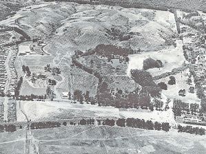
Cities rushed to annex land that extended their boundaries to the far western hills, area that had not been usable up to this time except for cattle grazing, flower growing and vegetable farming. Because of the rugged terrain, various dairies had used the land only for their cattle since the 1700s.
In the early 1900s, the vegetable farmers and flower growers began using more and more of the land as the dairy industry moved to the coast and elsewhere. Almost all of the more desirable and available flatland by the Bay was developed first but, by the mid- 1950s, the onslaught of the western hills had begun.
George Williams was a prime developer in San Bruno along with his partner, Frank Burrow. In Daly City, Henry Doelger began the onslaught of the sand hills after removing the pig farmers and vegetable growers before he developed the Westlake area. This development of homes, apartments and a giant shopping center continued south of Westlake by the Gellert brothers in the Serramonte area.
The pace of construction was fast and furious and employed thousands of workers who stimulated the economy. The population of Daly City increased from 15,000 to more than 60,000. David Bohannan in San Mateo was a very aggressive builder of many thousands of houses and the Hillsdale Shopping Center. Andres Oddstead put his mark on housing development in South San Francisco, Pacifica and in San Bruno. Between 1955 and 1965, San Bruno had been completely transformed in the western hills and the population was reaching for the 30,000 mark, up from approximate 4,019 in 1940. It would reach nearly 40,000 by 1994. The Joseph Eichler homes of South San Francisco and the Peninsula became noted for a new type of abode for thousands of families.
Recommended for you
Eventually, the tidelands were assaulted as T. Jack Foster developed a vast expanse that became Foster City. Thousand and thousands of people moved in during the ’50s and ’60s and created a great deal of environmental problems with sewage and solid waste that had to be disposed. The cities became aggressive for taxation to pay for the infrastructure but in 1978 they were thwarted by the passage of Proposition 13 that controlled the tax rate for a while.
The western hills of Millbrae had been assaulted for its dirt beginning in 1944 when the Macco Pit was created in what is now Millbrae Meadows. The 40 million cubic yards of dirt removed from this area were needed for the expansion of the San Francisco Airport and construction of a new Bayshore. Hauling of dirt lasted until the early 1950s. Shortly afterwards, housing construction was begun by the Stoneson Corp. and Millbrae Meadows was developed. The Millbrae Highlands development had already pushed west of the Junipero Serra Freeway spur property, and it was soon reached Skyline Boulevard. Along with numerous other developments that filled in the empty acres from Trousdale Boulevard to Helen Drive in Millbrae, the area became maxed out for houses. Very little property was left vacant by the end of the ’70s.
Fueled by this rapid increase a population, the San Francisco Airport became a prime county employer. Parallel to this was the development of the business parks such as developed in eastern South San Francisco and this replaced the steel and cattle market that had been the mainstay since the 1800s.
During the late 1940s, the electronics industry had become active on the Peninsula and EiMac in San Bruno fueled the economy with its booming business. The electronics industry moved south as land became available around San Carlos. The shallow water of the Bay that had been utilized for oyster growing by the Morgan Oyster Company became a temporary potential for more developed land as large companies wanted to fill in the Bay for housing near the airport. The use of these tidelands for housing was halted by people concerned that the Bay would be filled in at the expense of much-needed open space. The shallowest tidelands to the north of Burlingame and San Mateo were taken by a company that began to develop land for commercial development. The undeveloped San Bruno Mountain land offered prospective sites for numerous housing and landfill projects, but luckily, clearer heads prevailed and the mountain was preserved as open space.
In 1940, San Mateo County (with 447 square miles) had a population of approximately 111,800. By 2008, it was more than 700,000. The state had passed the 38 million mark in 2010.


(0) comments
Welcome to the discussion.
Log In
Keep the discussion civilized. Absolutely NO personal attacks or insults directed toward writers, nor others who make comments.
Keep it clean. Please avoid obscene, vulgar, lewd, racist or sexually-oriented language.
Don't threaten. Threats of harming another person will not be tolerated.
Be truthful. Don't knowingly lie about anyone or anything.
Be proactive. Use the 'Report' link on each comment to let us know of abusive posts.
PLEASE TURN OFF YOUR CAPS LOCK.
Anyone violating these rules will be issued a warning. After the warning, comment privileges can be revoked.